

In late June we started a housesit deep in the Welsh countryside, not too far from the Brecon Beacons. We had two ponies, four ducks and five sheep in our care, all of whom only required feeding early in the morning and late in the evening. Our homeowner encouraged us to get out and explore the local area, so we had all day to go hiking in this beautiful part of the U.K. We set ourselves the goal to hike Pen Y Fan before our five day stay ended, the main obstacle being to find a good weather day!
Overview
The tallest peak in South Wales, Pen Y Fan stands at 886 metres and is nestled in a group of other staggeringly high mountains. The mountain itself and the land around it are owned and maintained by the National Trust, which we’re always glad to see as it means paths are well-managed – even if they are winding along cloud-height mountain ridges! We chose the horseshoe ridge path to scale Pen Y Fan, which is the toughest route as it includes four peaks – Corn Du, Pen Y Fan, Cribyn and Fan Y Big – on a 16km loop. It took us just under six hours of hiking (with plenty of photo and snack breaks) to complete the route, so if you’re looking for a shorter route you might try starting at the Pont ar Daf car park at the bottom of Corn Du, and walking up to Pen Y Fan from there – this route takes just over an hour to reach the summit from the car park.

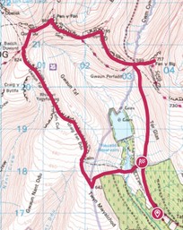
The route
For us though, our day began at the Taf Fechan Forestry Commission car park. The first twenty minutes or so takes you along a jagged stone path running parallel to a field of sheep, who scattered all around us as we followed the path over a stile and through their field. On the other side of the field, there’s a reservoir to cross before a steep stone path up to the ridge that towers above you. Our advice for this part of the route, and for all of the route really, is to TAKE YOUR TIME! While a well-trodden path has been carved by the hundreds of thousands of hikers who visit the area each year, there’s still a lot of loose stones and in parts you’ll have to scramble over rocks to get to the top. This first ascent to the top of the ridge is very steep, and even though we consider ourselves fit and healthy people, we stopped multiple times to catch our breath. That being said, it gave us a chance to appreciate the view – such a steep climb makes for stunning views in a short space of time!
When we made it to the top of the ridge we walked a short 50 metres to hit the trig point – always a good way to mark your accomplishment! We were grateful that we had overcast weather on the day of our hike – not too warm, not too cold – though at the top of the ridge the wind was a lot stronger. We made our way along the ridge, taking care to tread as far from the ridge edge as possible without damaging the land on the other side of the path. Fog rolled in and out all day as we walked the route and enveloped the paths ahead. So much so that, along this first ridge, we couldn’t even see Corn Du and Pen Y Fan in front of us. We made sure to take it easy along the path, especially with howling winds picking up just before Corn Du! We tried to take videos of the panoramic views along the ridge during a break in the fog, but the noise from the winds made it unpleasant to listen to!
When we made it to the ridge just before Corn Du the winds had thankfully died down, though the rolling cloud of fog remained. There’s a fork in the path that leads to the Pont ar Daf car park to the left, and the Corn Du peak to the right. It’s a short scramble to the top of the mountain over unusual, square-shaped rocks jutting out of the ground. The peak is small in surface area, and we found ourselves amongst a group of people taking time to enjoy their lunches, in lieu of enjoying any kind of view through the cloud. As such we didn’t spend much time on Corn Du, but we were also excited to get to the summit of Pen Y Fan!
Reaching the summit!
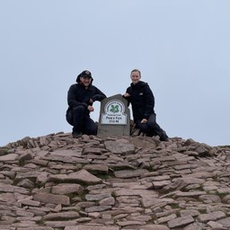
At this point in the hike we were about halfway round the horseshoe route, where the shorter route joins the path. Because this area sees more footfall, the ridge has sturdier paths with purpose-built stone pathways and wooden handrails to help those climbing Pen Y Fan. After a short while, the pathway turns to a pink, dusty-coloured rock and we made our way upwards. Still shrouded in fog, we followed another hiker through the cloud towards a small cluster of stones. As we got closer, we saw the National Trust plaque marking the summit! We spent some time here catching our breath, taking commemorative photos and letting the feeling of accomplishment sink in! It seemed everyone around us felt the same, as we spoke to other hikers in high spirits and took photos for them. It’s worth stopping to appreciate the climb at this, the highest point, during the hike. You might think it’s all downhill from here but there are still two peaks to go!

Enjoying this post? Help support our blog by leaving a tip from as little as £1!
With the cloud all around us showing no signs of shifting, we began to head down along the ridge to the next peak – Cribyn. The eerie silence on the path made for a really unique atmosphere, as we found ourselves alone on the pathway. A sudden flurry of noise and we turned to see a fox hurtling along the ridge pursued by three crows protecting their nests in the long grass. After they disappeared, the trail was silent once more. Unfortunately, the ridge route isn’t straight all the way along and at more than a few points you have to make your way down in order to come back up! However, this does mean that when we were halfway up the climb to Cribyn, we looked back for an incredible view of Pen Y Fan through the clearing fog. It helped us realise how far we’d come and how much we’d already accomplished, and motivated us to reach that next peak. At around 90 metres lower than Pen Y Fan, the path to Cribyn is still steep and strenuous and we took things slowly. Stones protruding from the mountain form natural steps and it’s a good place to sit and admire the landscape.
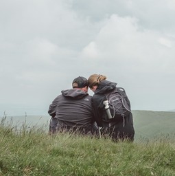
It’s hard to describe how breath-taking the views are all along this hike – not least because you’ll need to catch your breath at regular intervals. The panoramic views all around make this a truly spectacular hike.
Descending the ridge from Cribyn in the sunshine, making our way down steep, jagged steps, we saw the old roman road that snakes along the valley below. At this point in the route, it’s possible to turn right at the crossroads in the path and cut out Fan Y Big from the hike. As we were already exhausted from the previous three peaks, we thought about doing so, but being so close kept us motivated to endure one last climb and make our way to the top of Fan Y Big. This was probably the slowest we walked all day – by this point we were so tired from waking early to get walking, paired with the strenuous route and howling winds we’d experienced earlier in the morning, that we all but crawled up that last path. Once at the top, we were rewarded for our efforts with a stunning view all along the ridge and down the valleys, where we heard the soft, distant bleating of sheep being herded into lines – from where we sat they looked like little white ants. There’s a slab of stone that juts out over the valley below, colloquially known as ‘the diving board’ due to its shape and position in the mountainside, where we took some time to admire our surroundings and rest our tired legs.
The descent to the path below took just as long as coming up, as the gradient of the hill paired with it’s winding shape and loose, craggy stones required us to take extra care. We met two red-faced hikers who were being ‘helped’ (pulled) up the mountain by their two excitable dogs! Once at the bottom, it’s simply a case of following the dusty stone path all the way along the fields, past the reservoir, back to the car park when we began the hike. The sun even came out to bathe us in its golden rays, almost like a warm hug for our achievement.

Things to consider
This hike was incredibly strenuous, even for avid hikers like ourselves, and it’s not one we went into lightly. It’s never felt so good to sit down in the car! You better believe we had a slow and lazy day the following day too, simply enjoying being at home and admiring our small holding and temporary pets in their fields. If you’re thinking about hiking this route yourself, we have a few tips that will help you have the easiest hike possible:
- Check the weather and plan your outfit accordingly. We both wore water- and wind-proof jackets on this hike, taking them off when we got a little warmer climbing upwards and putting them back on to keep out the wind chill on descents. We also packed waterproof trousers in case of sudden rain, as well as sunglasses! Let’s face it – it’s Wales, you need to be prepared for all kinds of weather. This takes us onto…
- Footwear! Oh man, the sheer amount of people we saw hiking the horseshoe route in simple shoes or street wear trainers. There were points in the route that we slipped or stones on the path moved from under our feet, and we were both wearing proper hiking boots. On those paths, at that height, a small slip can become dangerous really quickly. Please, please, please wear proper hiking shoes!
- Take a map. Another highly important one – we would never have completed this route without researching it first and then bringing a map. We’re subscribed to the OS Maps app on both our phones, and had the route downloaded before we began as well as fully charging our devices. Without this, we would have taken a paper map.
Ten minutes into the route, a group of people in chino shorts and trainers asked us for directions – they were trying to use their data on Google Maps to navigate the route. They also asked us if the route was sign posted… *face palm*. While hiking the ridge an hour and a half later, it shocked but didn’t surprise us to see them tramping and stumbling through the long grass in the fields below in the opposite direction, having taken a massive detour. To refresh: The route, with a map to guide us, took us almost six hours. These guys added to their route unnecessarily by being dangerously unprepared.
- Start early. In the height of summer, to avoid walking the route with hundreds of others, start your day early. This almost means you avoid the hottest part of the day as much as possible, and allows for rest stops – the route may take longer than you think. The car parks also tend to get very busy, even mid-week, so to avoid missing out get there as early as you can!
- Stretchhhhh! As with any hike, it’s definitely worth taking the time to stretch out your body before and after! We felt this hike in muscles we didn’t even know we had.
- Bring enough water and food. Last but not least, if you know Suze you’ll know that her backpack is mostly filled with snacks. For this hike we had three kinds of trail mix, crisps, and celebratory Percy Pigs for the end of the hike all crammed into that backpack. We cannot stress enough how strenuous the route is, and you’ll need to make sure you’ve got the energy to climb every one of those peaks. We had three canteens of water with us, and one more in the car just to make sure we had enough, and that was on a mild day. The route is also safe for dogs, if you know your dog will walk with care, and it’s important to bring provisions for them too.
If you found this post helpful, please support our blog by donating as little as £1 to our running costs! Thank-you!


We are Chris+Suze
Related Posts


Stasher Snack Pack
This Silicone snack bag is the perfect, environmentally friendly, way to carry nuts, seeds, dried fruit and any other small snack when walking a dog or hiking up a mountain. Simply fill it up, seal it closed and chuck it in a bag and you are ready! Chris makes sure to always bring this on long walks, just in case for when Suze gets snacky!

Insta360 GO 2
We LOVE this tiny portable camera! We attach it to ourselves using the accompanying magnetic necklace when we timelapse hikes, and it can fit on a dog harness to capture live dog cam footage of our walkies! A must-have for travellers, for a unique way to capture every adventure from your perspective!

Garmin Fenix watch
We both have Garmin Fenix watches as we love to record all the dog walks, hikes, runs and other activities that we do! It’s easy to sync up this watch with your smartphone to analyse all the data too.

First aid kit
No matter where you’re travelling, owning a well-equipped first aid kit means you’re prepared for minor injuries, sudden illnesses or emergencies. It’s especially essential if you’re on a road trip in an unfamiliar place, or remote areas where you may find yourself far away from the nearest pharmacy, doctor or hospital.

